-
 Hi Guest!
You can help ensure that British Car Forum (BCF) continues to provide a great place to engage in the British car hobby! If you find BCF a beneficial community, please consider supporting our efforts with a subscription.
There are some perks with a member upgrade!**Upgrade Now**
(PS: Subscribers don't see this gawd-aweful banner

Tips
- We have a special forum called "Member Articles" where you can submit actual articles for consideration for publication. Learn More
- Don't have an Avatar? If not, your avatar will default to the 1st character in your username. Go into "Account Details" to change your Avatar.
- Some basic forum navigation info: click
 Hey - did you know if you click on the title of a thread it will take you to the first unread post since you last visited that thread?
- Hey Guest - Is your British Car Club in our Clubs database? If not, send me a PM - Basil

- Looking for a local club? Click the "Clubs" tab above and browse hundreds of clubs world-wide.
- Add Android or iPhone APP: click
- Did you know - any picture or video you add in your posts in any marque-specific forum will also get added to the Media Gallery automatically.
- A few more tips about posting and replying: click
- Hey there Guest - be sure to keep your profile page up to date with interesting info about yourself: learn more
- More tips and tricks on Posting and Replying: click
 but were afraid to ask:
  STOP!! Never post your email address in open forums. Bots can "harvest" your email! If you must share your email use a Private Message or use the
  smilie in place of the real @
- Want to mention another member in a post & get their attention? WATCH THIS

- So, you created a "Group" here at BCF and would like to invite other members to join? Watch this!
- Hey Guest - A post a day keeps Basil from visiting you in the small hours and putting a bat up your nightdress!
- Hey Guest - do you know of an upcoming British car event?
 Pretty Please - add it to our Events forum(s) and add to the calendar! >> Here's How <<
- Hey Guest - you be stylin' Change the look and feel of the forum to fit your taste. Check it out
- If you run across an inappropriate post, for example a post that breaks our rules or looks like it might be spam, you can report the post to the moderators: Learn More
- If you would like to try some different "looks" or styles for the site, scroll to the very bottom, on the left and click the Style Selector.
You are using an out of date browser. It may not display this or other websites correctly.
You should upgrade or use an alternative browser.
You should upgrade or use an alternative browser.
Guess who
- Thread starter Basil
- Start date
aeronca65t
Great Pumpkin
Offline
Can't guess Who....but somewhere in the middle of Florida?
OP
Online
aeronca65t said:Can't guess Who....but somewhere in the middle of Florida?
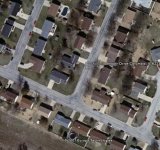
Yes...if you use Google Earth you will probably figure it out very quickly.

OP
Online
martx-5 said:I don't know who, but google earth puts it here in Florida...
That is not quite the right local - Let me double check my numbers (I'm using Google Earth on the desktop)
terriphill
Darth Vader
Offline
Oh wow! isn't that just huge amounts of fun and hours of looking things up. My kids at school will love this!
Harry_Ward
Jedi Knight
Offline
S=Q/T? A little east of Orlando?
OP
Online
terriphill said:Oh wow! isn't that just huge amounts of fun and hours of looking things up. My kids at school will love this!
You would be amazed at some of the stuff I've found with Google Earth - like a WWII shipwreck for example.
OP
Online
Harry_Ward said:S=Q/T? A little east of Orlando?
Quite a bit north and a bit west of Orlando I'm afraid.
terriphill
Darth Vader
Offline
How often do they update the sattelite data? Like if we created a message on our football field, how long before it would appear on thew sattelit pic? I can't tell, but a ouse near us burned just after hte first of the year and it appears to be there in the image I am looking at.
OP
Online
terriphill said:How often do they update the sattelite data? Like if we created a message on our football field, how long before it would appear on thew sattelit pic? I can't tell, but a ouse near us burned just after hte first of the year and it appears to be there in the image I am looking at.
It is definitely not real-time data. I suspect the update time depends on where you are looking and what satellites are used to take the images. In my neighborhood the images are a few months old.
Basil
OP
Online
jaybird said:What's Google Earth?
Its a free download from Google that puts the earth at your finger-tips. You can scan and scoll and zoom in to your hearts content and see just about any place on earth with pretty decent resolution:
Attachments
Harry_Ward
Jedi Knight
Offline
Basil,
I Just down loaded google earth. Pretty cool! Thanks now I don't have to guess anymore. You are in what appears to be a small airport with a small golf course around it judging by the scale. I have no idea how to post the image? Either that or it's somebodys private mansion with an airport and golf course attached.
I Just down loaded google earth. Pretty cool! Thanks now I don't have to guess anymore. You are in what appears to be a small airport with a small golf course around it judging by the scale. I have no idea how to post the image? Either that or it's somebodys private mansion with an airport and golf course attached.
OP
Online
Harry_Ward said:Either that or it's somebodys private mansion with an airport and golf course attached.
You're getting VERY warm!